
Over 12 million years ago during the Miocene epoch , two massive volcanoes erupted from the sea floor at 50⁰ South near the western edge of the Campbell Plateau, a shallow area of continental shelf extending 1100 km south of New Zealand. The resulting shield volcanoes formed what is now known as the Auckland Islands. Over millennia the islands have been eroded by sea, wind and glaciers, creating a rich and varied geology that gives the islands their unique and dramatic appearance.

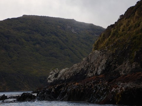
Capped with cloud and volcanic plugs, view of Auckland Island’s east coast.
Made up of 7 islands and numerous small islets (map), the Auckland Islands lie 460 km south of New Zealand in the Subantarctic Convergence zone. On average it rains (or sleets or snows) 300 days of the year, winds of more than 60km/hr blow year round and the temperature rarely reaches above 15⁰ in summer and 6⁰ in winter. Declared a Nature Reserve by the New Zealand government in 1934, the Auckland Islands are part of the NZ Subantarctic Islands World Heritage listing. Auckland Island, the largest of the group, and Adams Island, the most southerly, form the group’s bulk and cradle the deceptively calm anchorage of Carnley Harbour. Enderby, Rose, Ocean and Ewing Islands sit at the northern tip of the group, and Disappointment Island lies approx. 15 km to the west of Auckland Island, exposed to the perpetual westerly winds and sea currents of the Furious Fifties. Sweeping around the world, these winds and currents dash against Auckland and Adams Island’s western and southern coasts, eroding sheer cliffs of columnar basalt, in places up to 500 m high, holed by sea caves. The eastern shores show the island’s history of glaciation during the last ice age. Dozens of fiord-shaped inlets arrow into dense green rata forest, bordered by angular, towering basalt and granite cliffs. 39 km long and varying in width from 5 to 12 km Auckland Island rises abruptly from the sea, capped by volcanic plugs and sudden mountains reaching over 600 meters above sea level. Moraine dammed small lakes are contained by steep, glacial carved valleys that channel swift winds and rainfall.
Glacial carved entrance to Musgrave Inlet, Auckland Island
Most of the islands’ coastlines are steep cliffs with rock outcrops and platforms jutting from their bases. Fringing the coasts are rich swathes of kelp including the huge bull kelp Durvillaea antarctica, providing habitat for molluscs, crabs, krill and other marine life. Moving up from the salt spray zone the steep cliffs sprout hardy shrubs like Hebe, and megaherbs including Anisotome, Stilbocarpa and Bulbinella are interspersed with tussock grasses and spiky Dracophyllum, eventually capped with rata forest. Almost impossible for humans to access, these cliffs and rocky shores are ideal habitat for Subantarctic wildlife. Sea lions, penguins and seals can be seen on the rocks and feeding in the kelp, alongside endemic Auckland Island Teal, terns, petrels and other sea birds. Light Mantled Sooty Albatross and mollymawks nest in the rocky hollows of the cliffs, tomtits dart amongst the leaves picking off invertebrates.
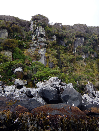
Auckland Island cliff face showing vegetation transition from kelp to rata forest, with a few Southern Rockhopper penguins in the foreground.
The compact but varied topography of the Auckland Islands has resulted in highly diverse vegetation, made all the more striking by being contained in such small land areas. There are 233 documented plants species in the Auckland Islands, with 196 of these indigenous to New Zealand and at least 5 unique to the Islands. Over millennia the dense vegetation has formed thick layers of peat, in places up to 5 meters deep and perfectly suited to the complex and unique flora of the islands. Auckland Island itself supports thick forests of southern rata and the world’s most southerly tree fern, megaherbs, tussock grasses, herb fields and alpine heath. Enderby Island boasts one of the few sand beaches and dune complexes in the island group at Sandy Bay, as well as the rata forests, megaherbs, heaths and tussocks found on the main island.
The island’s acidic peat defeated two attempts at colonisation in the 19th century, following the island’s documentation in August 1806 by Abraham Bristow, captain of the ship Ocean. The first documented attempt at settlement was by a group of Maori and Moriori from the Chatham Islands. They arrived in 1842 and the final members of the community left in 1856, making their colony the longest-lived attempt at settlement. During the time of the Maori settlement there was an ill-fated attempt at English colonisation, after the English Crown granted Charles Enderby the Auckland Islands in 1847. He made plans for a whaling settlement and somehow managed to recruit 200 people to join him. The first ship of colonists left England in 1849, and the settlement struggled from the start. Despite the green and lush appearance of the islands, the acidic peat soils were hostile to all attempts at cropping and the whale, seal and sea lion populations already in decline from heavy harvesting. In 1852 the last English settlers departed the islands, leaving only a few broken down huts, a small cemetery and a thriving population of cats, rats and pigs. These pests continue to impact the islands ecology today, except on pest free Enderby Island.

Megaherbs on Enderby Island

Enderby Island sand dune complex
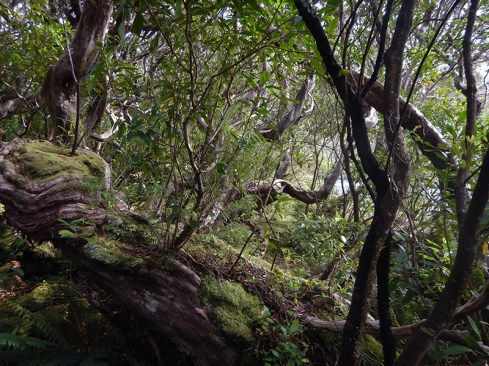
Dense rata forest on Auckland Island
In this section:
Journals and photos from two days on the Auckland Islands:
