
Mention Macquarie Island and the first image that springs to mind might be overflowing penguin colonies, imposing elephant seals and ravenous skua gulls. But it was primarily the island’s unique geology, rather than wildlife, that saw it listed as a World Heritage site in 1997. Unlike other islands, formed by volcanoes or raised areas of a continental shelf, Macquarie Island is totally oceanic in origin, a part of the ocean floor from as deep as 6km below the surface raised above sea level by tectonic forces. No where else on earth can humans walk on ocean rocks from this depth.
The island is thought to have begun as an underwater ridge, shaped by sea-floor spreading between 11 and 30 million years ago. At some point the spreading stopped and the area of the Earth’s crust that formed that region of the ocean floor began to compress, squeezing rocks from deep within the earth’s mantle upwards along the present-day ridge line. Unique geological features that chart the islands rise from the sea floor, like the rocky forms known as pillow basalts, are still visible today. These processes pushed the island above sea level approximately 600,000 years ago, and continue today making Macquarie Island one of the most geologically active areas of Australia. It is currently rising at a rate of about 0.8 mm per year. Evidence of old beaches can be found on the island from close to the highest point, down to the beaches of the present day. Sediments on these beach deposits have been studied and their ages have been used to understand the Island’s upward movement (Selkirk et al., 1990).
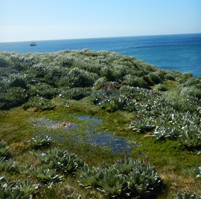
A small beach terrace peat bog
Macquarie Island is the highest point of the Macquarie Ridge complex, a 1600 km series of deep trenches and high ridges on the ocean floor reaching south-west from New Zealand’s South Island, along the eastern edge of the Pacific Tectonic Plate to the junction with the Indo-Australian Plate and the Antarctic Plate, known as the Macquarie Triple Junction. Running along the boundary of tectonic plates for most of its length, the ridge is very geologically active and earthquakes are not uncommon on Macquarie Island.
Being the high point on an under-sea ridge, the sea floor around the island drops very sharply from the shore line. Running for 480 km along the east of the ridge the Macquarie Trench plunges to over 5.5 km deep, with an average depth of 4.7 km. These cold, deep waters have been mapped with bathymetric and gravity studies. Depths in the ocean floor can be mapped by measuring variations in the Earths gravity field in a particular location (Selkirk et al. 1990).
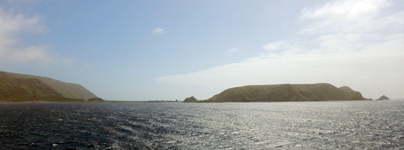
The island is continually buffeted by the wind and waves of the Southern Ocean, and sea stacks and islets located off shore and along the coast clearly show the effects of these relentless forces on the uplifted rock. To the north and south of the island are small rocky islets, which like the island itself are part of the top of Macquarie Ridge. Judge and Clerk Islet are to the north of the island, with Bishop and Clerk Islet to the south.
As the island is so entirely isolated in the middle of the ocean, with no connection to any continental land mass it is generally thought that unlike parts of New Zealand and other Subantarctic Island like Heard Island, it was not covered by ice sheets or glaciers in the last ice age. Until the mid 20th century there was still some debate about the possibility of glaciers shaping the island, with some suggestions that the topography was created by glaciers scouring out depressions and leaving rock deposits. But there is another explanation, which is part of the islands unique geology.
Faulting, the process by which sections of the earth’s crust are uplifted or moved by tectonic forces, has played a major part in the formation of Macquarie Island. There are four main and numerous smaller fault lines on the island, and this process has been the predominant force in shaping the islands landscape. The type of faulting occurring in and around Macquarie Island is known as ‘strike-slip’ faulting, where sections of rock are moved quickly against each other by movements in the earth’s crust. With so many faults in such a small area – the island is only 34 km long and 5 km at its widest point – this faulting process has created a steep and dramatic landscape.
The isthmus and Wireless Hill on the islands north east corner are a prime example of faulting on the island. Wireless Hill is a relatively high, isolated raised bulk of rock joined to the main body if the island by a 200 meter long isthmus. There is a major fault across the isthmus at the base of the hill, which may have played a role in its uplift above the nearby land. Wireless Hill was named by Douglas Mawson when it was identified as a prime site for installing a radio-relay station and weather monitoring equipment. The main area of human settlement is located on base of Wireless Hill at the end of the isthmus, as it is the only relatively flat area of land on the island accessible from the sea.
Looking towards the station base on the isthmus (you can just make out the geodesic dome) with Wireless Hill at the right
But the isthmus is not the only area of flat land on Macquarie Island. A plateau runs for most of the island’s length, along the top of the uplifted rocky mass. Dropping down in sudden steep terraces and gullies to the beaches below, the plateau is dotted with numerous lakes and ponds, providing a very different habitat to the coastal fringe. The Macquarie Island Geoconservation Strategy 2014 describes the faulting process and its role in creating the islands lakes and landscape in more detail.
Lakes
While there are no rivers on Macquarie Island, gullies, small creeks and drainage lines are formed both by faulting and erosion from the almost constant rain and wind. With high rainfall and low evaporation rates, this abundance of freshwater feeds more than 26 documented lakes and ponds on the island. There are multitudes of drainage lines flowing down the steep slopes of the island plateau to the ocean below, some forming lakes and ponds in the water-logged peats of the coastal terraces that step down towards the shore. On the plateau itself there are numerous small creeks and gullies flowing into depressions in the peat, forming ponds and small lakes. Alongside the peat lakes, lakes and ponds formed by faulting dot the plateau. These are created when faulting dams an established watercourse, or creates a depression which is then filled with run-off from the surrounding area. Most of the smaller lakes and ponds on the island are quite shallow, but the larger ones can reach a depth of more than 30 meters. Prion Lake has been measured to a depth of 32 meters, with Waterfall Lake not far behind at 25 m deep (Selkirk et al., 1990). There is one established aquatic plant in the lakes and ponds of the island, Myriophyllum triphyllum, sedges and some herb species thrive in the surrounding wet and boggy areas. The lakes and ponds all host a range of freshwater algae and mosses, which support invertebrates including copepods, flatworms, nematodes and insect larvae. It would be fascinating to visit one of the lakes on the island, but tourists are not permitted on the plateau.
In addition to the links in this article, two essential sources were:
P.M Selkirk, R.D Seppelt, D.R Selkirk. 1990 Subantarctic Macquarie Island Environment and Biology Cambridge University Press
Parks and Wildlife Service, 2006 Macquarie Island World Heritage Area Management Plan, Parks and Wildlife Service, Dept. of Tourism, Arts and the Environment, Hobart.
