The term Subantarctic is defined as ‘of, pertaining to, similar to, or being the region immediately north of the Antarctic Circle; subpolar.’ The term has a number of variations on capitalization and hyphen use including subantarctic, Sub-Antarctic and sub-Antarctic. For this website I’ve decided to stay with the term Subantarctic.
When I tell people I’m heading to the Subantarctic, the response is often along the lines of ‘Antarctica? You’ll see a lot of ice’. Unlike the fixed, charismatic bulk of Antarctica, sitting squarely in our ideas of the earth’s penultimate freezing south, the Subantarctic is a world encircling, oceanic, almost landless region.
Forming the northern edge of the Southern Ocean, the Subantarctic can be loosely defined as the northern waters of the Antarctic Circumpolar Current where the cold northerly flowing waters of the Antarctic Polar Front, also known as the Antarctic Convergence mix with and sink beneath the warm, southward moving waters of the Subtropical Front. The Biogeographic Atlas of the Southern Ocean explores this complex system in more detail.
Ranging between the 42nd and 58th southern parallels of latitude, the Subantarctic cannot be described by straight lines on a map. The sinuous oceanic fronts bordering the region are influenced by atmospheric forces from above and the topography of the ocean floor below. Spreading over the deep basins and wide plateaus of the southern Atlantic, Indian and Pacific Oceans to surge through the sharp pinch of the Drake Passage between South America’s southern tip and the Antarctic Peninsular, Subantarctic waters are in perpetual motion around the base of the earth’s globe.
The dynamic and non-liner nature of Subantarctic oceanic fronts is best illustrated by the environmental differences between Macquarie Island and South Georgia, both of which lie on the 54th southern parallel of latitude but on the north and south side, respectively, of the Antarctic Polar Front. As first compared by the Russian navigator Captain Thaddeus von Bellingshausen in 1820, Macquarie Island is a green refuge supporting thriving stands of tussock grass, endemic Macquarie Island cabbage (Stilbocarpa polaris, the roots of which were used as an early scurvy remedy by sealers left on the island for months, and exploratory expeditions) and megaherbs, while South Georgia is bound year round with ice, snow and glaciers. This is due to a major northward curve in the ocean fronts after they pass through the Drake Passage, drawing up cold Antarctic waters around South Georgia.
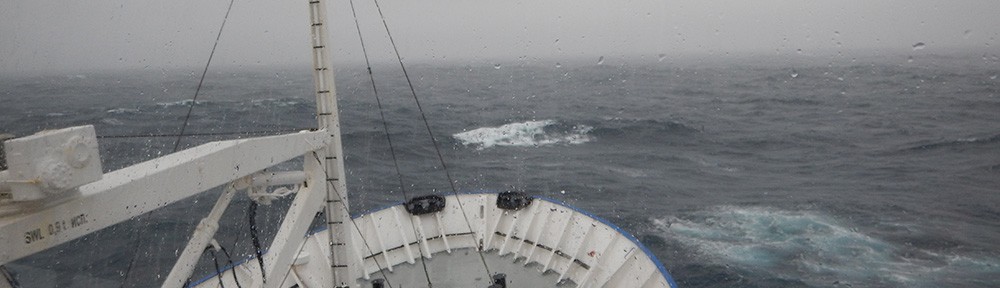
While the Subantarctic is certainly cold – summer temperatures rarely hit double figures – it is more wet and windy than consistently ice bound. For instance, Macquarie Island averages 900 mm of precipitation per year. The freezing icebergs of Antarctica do not always survive far into the Subantarctic, at least during summer, but snow, sleet and hail are common, driven by the constant winds of the Roaring Forties and Furious Fifties. The islands below Australia and New Zealand visited on my trip (The Snares, Auckland Island, Macquarie Island and Campbell Island) do not support glaciers, but are frequently covered in snow through the long southern winter. Some Subantarctic islands do have glaciers, Heard Island and South Georgia being 2 examples.
Characterised by the mixing of cold, nutrient rich Antarctic waters with warmer currents from the north, the Subantarctic region is filled with marine life and biological diversity. Despite a long history of exploitation the islands of the Subantarctic now provide secure breeding grounds for literally millions of marine mammals and birds, and habitats for highly specialised plants, many of which cannot be found anywhere else in the world.
There are 22 Subantarctic island groups scattered around the base of the world, claimed by Australia, New Zealand, Norway, France, the UK and South Africa. Largely uninhabited by humans since the mid-20th century, the value of these islands as wildlife refuges has become well recognised. Australia’s three Subantarctic island groups – the Heard and Macdonald Islands and Macquarie Island – are listed on the World Heritage register, as are New Zealand’s Subantarctic islands, for their outstanding environmental, historical and geological values. Of these island groups Macquarie Island is currently the only one with a year-round human presence, supporting a staff of rangers, technicians and researchers.
On a planet packed with more than 7 billion people, the Subantarctic is not spared human impact or activity. There are long-established krill and finfish fisheries throughout the region, and in recent years tourism in the Subantarctic has gained pace.
While Antarctica draws the bulk of tourists below the 48th parallel, expeditions to the regions south of New Zealand and Australia have increased. The islands can still only be visited by boat, and eco-tourism expeditions, like the one I traveled on are becoming more frequent features of the Subantarctic summer.
To manage this relatively new industry, the Australian and New Zealand governments have developed guidelines and protocols for tourism operators to minimise impacts from tourism, primarily the Guidelines for Tourist Visits to Macquarie Island Nature Reserve and World Heritage Area (Australia) and the Subantarctic Minimum Impact Code (New Zealand). From decimated oil resource to tourism drawcard, the wildlife and landscapes of the Subantarctic have become a new kind of asset, and the wider world is once more paying attention to what happens in the Furious Fifties.
Despite this renewed interest the Subantarctic remains one of the last really wild places on earth, governed by implacable water and wind. I feel very fortunate to have had the opportunity to experience this truly remote region.
